
This morning, the front associated with yesterday’s thunderstorm activity stalled near the I-70 corridor with a humid and warm air mass in place in its vicinity.
WEATHER LINKS:
Current Conditions | School Closings & Delays | Submit Your Weather Photos
With light winds in place and high levels of humidity near the ground, this has resulted in the development of patchy fog.
KDKA Weather Center
The fog is generally thickest near and northwest of the Pittsburgh metro and will be in place through the next few hours. Some scattered showers are ongoing across Ohio and will move from west to east through sunrise and into the mid-morning hours. As low-level heating commences, this will allow instability to build up, resulting in a transition from showers to scattered and even numerous thunderstorms developing by 11 a.m. and 1 p.m. and lasting through the evening hours.
Similar to yesterday, wind shear values aren’t too high, but just enough to allow for pulse storms that could produce localized microbursts of wind up to 60mph, very heavy rain, and at most quarter-sized hail.
KDKA Weather Center 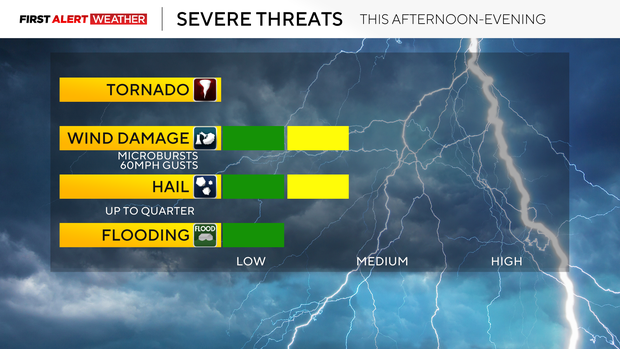
The bulk of the storm activity will shift south toward I-70 and I-68 during the late evening and overnight hours of Saturday. After a few morning showers, most of Saturday into Saturday night is trending drier as we will be in between systems with high pressure to the north.
On Sunday, moisture will return north ahead of another disturbance. It is likely that showers and numerous thunderstorms will move in during the midday to afternoon hours with this system. An isolated severe storm cannot be ruled out, especially south of Pittsburgh toward the I-70 and I-68 corridors.
Following Sunday’s system, a more potent upper-level storm system will move in on Monday into Monday evening. This system will have much stronger winds aloft and be accompanied by sufficient moisture and some instability, so we will need to keep an eye on a potentially higher severe weather threat with this system.
Lingering showers and storms will continue on Tuesday, before a cold front moves in, resulting in drier conditions by the following Wednesday through the end of next week.
KDKA Weather Center 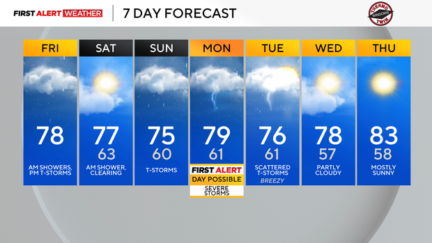
Stay up to date with the KDKA Mobile App – which you can download here!